
Best walking and trekking trails near Rome
Walking, hiking, and trekking routes at just “a stone’s throw” from Rome, all in the Lazio Region.
With its numerous paths and trails, Italy is a paradise for trekking lovers, and since the crisis linked to covid has limited the possibility of sport and movement, a hike in the fresh air is an excellent way to experience Italy’s outdoors while getting great exercise.
From the sea to the mountains, the Lazio region offers a range of landscapes and paths to shake off the constraints of Rome, open your eyes and stretch your legs. It is one of the best regions of Italy to combine nature, history and hiking. The vicinity to Rome, the cradle of the Roman Empire, makes Lazio a treasure trove for those determined to get outside, from children to history buffs, to athletes.
Here are 10 suggestions for walking, hiking, and trekking routes at just “a stone’s throw” from Rome.
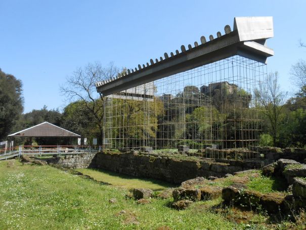
1. Necropolis and Waterfalls of Cerveteri
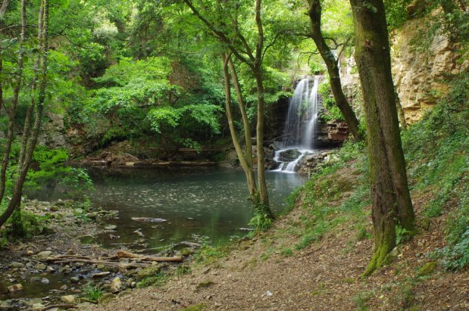
The first route on our list leads to Cerveteri Falls, a wonderful and little-known place. The ruins of a city that the Romans called Caere, and which was a wealthy Etruscan town, can be discovered through the Necropolis of Banditaccia. You can explore different types of Etruscan tombs, and it is one of the UNESCO wonders of Lazio . Here, local associations have collaborated to restore a part of the ancient remains.
Also read: Best lakes around Rome
After the visit to the Necropolis, continue towards the Via degli Inferi and the Necropolis of Laghetto. Among the most majestic points of this trek is are the natural waterfalls located at the end of the route. There is a bookshop, bar and picnic tables at the site of the Necropolis. Ceveteri has restaurants.
Starting Point: a dirt track just before you reach the town of Cerveteri leads to the Fosso della Manganella, which then leads to the archaeological area of the Banditaccia (this part is well-marked by road signs). The return route is the same.
Getting there from Rome:
By Bus: COTRAL buses leave from Lepanto Station (Metro A). The journey time is approximately 1 hour, depending on traffic in Rome. The bus stop in Cerveteri is a 25 minute walk from the archeological site of the Necropolis. By Car: Takes about 1 hour.
Walking time: 3 hours and 30 minutes
Route length: 5 kilometers
Best time to do it: Year round
Level of difficulty: Medium. Suitable shoes advisable due to watery ground.
Visit: The Necropolis of Banditaccia
2. Summit and hermitages of Monte Soratte
Monte Soratte is a singular mountain. It is 691 meters high and dominates the landscape from the Autostrada del Sole, the Via Flaminia and the two Rome-Florence railway lines. Beautiful and wild, it has been a destination for excursions since the late nineteenth century. Often called “the balcony of Rome”, as it boasts 360 degree views or the “Green Lung” for its well- preserved nature. Monte Soratte was used as a place of worship since ancient times.
Also read: Best day trips from Rome
You can admire the medieval church of San Silvestro, built on a temple of Apollo, which the volunteers of Avventura Soratte keep open on holidays for hikers. There are also the ruins of quite a few medieval hermitages. The hike will hopefully delight botanical enthusiasts. It starts with a trek half- way along the Tiber valley, over the summit ridge of the mountain, with wide views of the volcanic hills and the Apennine mountains. Don’t miss the medieval dwelling of Santa Romana, built in a cave, and the bunker used in 1943-44 by Field Marshal Kesselring, commander of the German troops in Italy (which can also be visited on guided tours of the tunnels and their peculiar history). Sant’ Oreste has a few restaurants and bars for lunch.
Also read: Exploring Rome’s Parks
Starting Point: From the center of the town of Sant’ Oreste follow the Via Degli Eremi road. There are a variety of well- marked paths to follow.
Getting there from Rome:
By Bus: COTRAL buses leave from Saxa Rubra (A line) and the journey time is 1 hour and 50 minutes. By Car: About 1 hour from Rome.
Walking time: 2 hours and 45 minutes
Route length: 3 kilometers
Best time to do it: Year round
Level of Difficulty: Medium. There is a steep point to reach the church and monastery.
Visit: The church of San Silvestro from the 6th century (on weekends or by appointment), the bunker of Monte Soratte, and the Natural History Museum of Monte Soratte.
3. Ring of Monte Calvio and Casalaccio
The Park of Veio spans from between the main roads via Cassia and via Flaminia and goes south along the Grande Raccordo Anulare. This green belt around Rome produces a mitigating effect on the climate and ensures continuity of the natural environment, protecting biodiversity.
Also read: Mountains become accessible to the disabled in Austria and Italy
The Park of Veio, despite having undergone urbanization processes in the past, is still intact and has therefore preserved a high value for its landscape. We propose you follow the trail that is a long ring, a short distance from the Flaminia road, which includes numerous ups and downs and allows you to reach some of the most interesting places in the park, including the summit of Monte Calvio. Although it is only 267 meters high, it offers a magical panorama and silence. The walk is simple, almost completely flat and recommended to those who love excursions with children, who will surely appreciate this place full of history immersed in the Roman countryside.
Starting Point: From the station of Magliano Romano, next to the junction of the provincial road to Campagnano on the Via Flaminia. Next to the road is a parking lot, just beyond is the “Ostello di Veio”. Follow an asphalt path to the entrance gate to the park.
How to get there: By car: 40 minutes from Rome.
Walking time: 2 hours
Route length: 6 kilometers
Level of Difficulty: Easy
Best time to do it: Year round
Hours: Monday- Friday 9.30am- 1pm
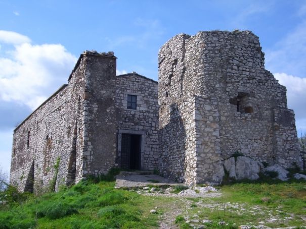
4. On the via Francigena: from Formello to Isola Farnese
The via Francigena is the aorta of Europe. It connects the English cathedral of Canterbury to St. Peter’s Basilica through France, Switzerland and five Italian regions. Then it approaches Rome, right through the countryside protected by the Park of Veio. The route we propose starts from the medieval village of Formello, guarded by a castle well worth a visit. Then continues along via di Monte Michele, a dirt road that leads to a necropolis. Finally, you wander around the ancient city in the southern part of the trek, Isola Farnese, a nature- filled gem in the heart of Rome. Here is where you can visit the Sanctuary of Portonaccio di Veio.
Also read: Canale Monterano: deserted village near Rome
Starting Point: From the central piazza of Formello, the medieval town where Palazzo Chigi stands. The return route is the same. Or: From via Cassia you can reach the town of Isola Farnese, with the beautiful fortress of the noble Roman family, and park near the church of San Pancrazio. Once the car is parked, go down the stairs that leave from the square and when you reach the main road, continue to the right. The Park of Veio is very well marked, at each junction you will find indications.
How to get there: By car: 40 minutes from Rome.
Journey time: 3 hours
Route length: 12 kilometers
Level of Difficulty: Easy
Visit: The Museo dell’Agro Veientano and the Shrine of Portonaccio
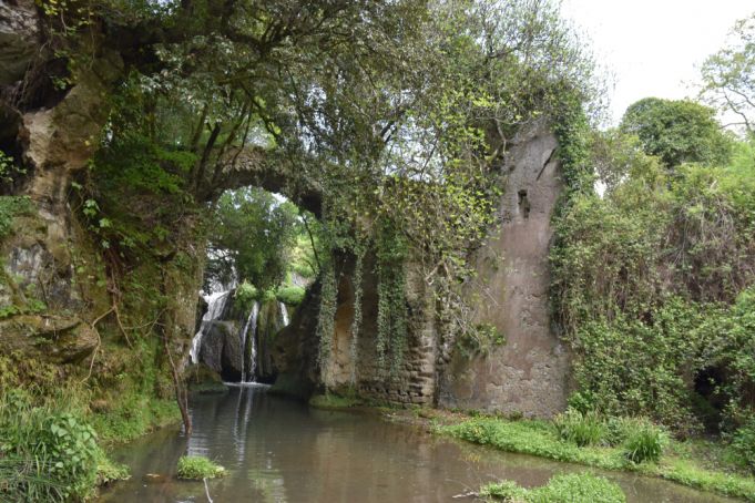
5. The Etruscan City of Veio
The park of Veio is one of the main attractions of the Roman countryside. Its vastness offers several possibilities for visits, with well marked paths. The name Veio refers to the ancient Etruscan city that once stood on the land. The charm of this place is provided by the Shrine of Portonaccio, built on the ruins of the temple dedicated to the goddess Minerva and dating to 510 B.C. Here you can admire the statue of Apollo, thrown into a ditch around 200 AD and found in 1916. But the most exciting part of this route is the Ponte Sodo. It is a seventy-meter tunnel dug by the Etruscans to allow the flow of the waters of the Cremera, now known as the Valchetta stream.
Also read: Wolves get close to centre of Rome
Starting point: The entrance to the archeological site is located on Via Riserva Campetti. Begin the trek at Mola waterfalls, continue to the Portonaccio shrine, and finish with the Ponte Sodo. Return route is the same. We recommend lunch at the Antico Mulino a Vejo restaurant near the waterfalls.
Getting there: By Bus: No. 32 to Isola Farnese/ Riserva Campetti By car: 40 minutes from Rome.
Journey time: 2 hours
Route length: 6 kilometers
Level of Difficulty: Easy
Visit: The Shrine of Portonaccio
6. Woods and plateaus of Monte Gennaro
Mount Gennaro is the mountain of the Romans. From anywhere in Rome you look, you can see it. With a height of 1300 metres, it dominates the city. It was the sacred mountain of Janus, hence the name Gennaro, and is the natural barrier to the east of the Roman countryside. The classic route to climb to the top of this mountain crosses the Cavalera Valley and then the Pratone (a large grassy field). We recommend an uphill hike, which allows you to overlook the Scarpellata gorge from above, and climbs directly from the small town of Mercellina, even if it is definitely more tiring.
Also read: Visiting the Vatican Museums: All You Need to Know
Getting there: By Car: 1 hour from Rome.
Walking time: 4 hours
The Route: one hour from Prato Favale to Pratone; one hour and a quarter from Pratone to Monte Gennaro; three quarters of an hour from Monte Gennaro to Pratone; one hour from Pratone to Prato Favale
Route length: 8 kilometers
Level of Difficulty: Medium
7. From Genzano to Nemi and around Lake Nemi
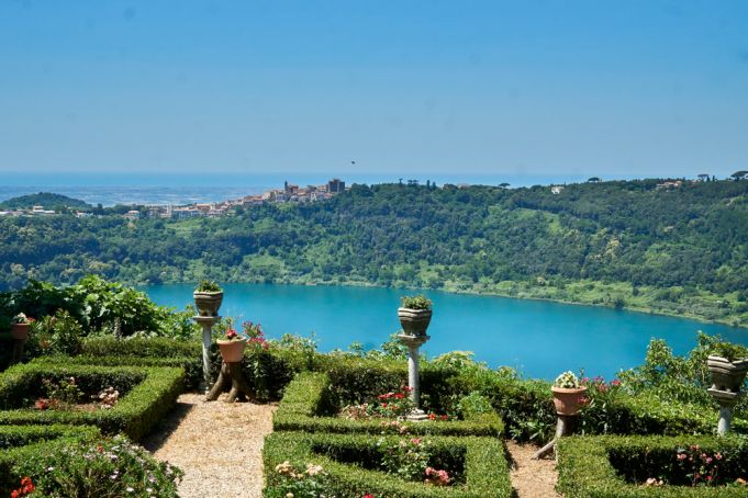
The trail from Genzano to Nemi and the lake offer beautiful places to walk. The medieval village of Nemi is one of the most alluring of the Castelli Romani area. The views stretch as far as the Tyrrhenian Sea on clear days. A delicious treat for those who choose to walk this routes that you can buy fragrant strawberries, also offered in bars and pastry shops.
Also read: All you need to know about lake Nemi
On the opposite bank of the crater belt of Lake Nemi is Genzano, a town famous for the Infiorata, which is celebrated during Corpus Christi. The walk that connects the two towns follows the road of the southern Francigena, reaches the Fountain Tempesta, then strays from the famous trail and continues towards the Piagge meadows, on the belt of Nemi Lake, up to the upper part of Genzano town. An easy descent leads to the lake and the Museum of Roman Ships, not to be missed. The excursion is a ring.
Also read: Must-see museums in Rome
Getting there: By Bus: From the Anagnina Metro stop in Rome, take the CoTral bus heading to Genzano. At Genzano, change buses, an get on the one marked Nemi. By car: 1 hour.
Journey time: 3 hours
The route: three quarters of an hour from Nemi to Fontana Tempesta; one hour from Fontana Tempesta to Piazza Dante Alighieri; half an hour from Piazza Dante Alighieri to the Museo delle Navi; one hour from the Museo delle Navi in Nemi
Route length: 9 kilometers
Level of Difficulty: Easy
Visit: Museum of Roman ships in Nemi
8. Amatrice
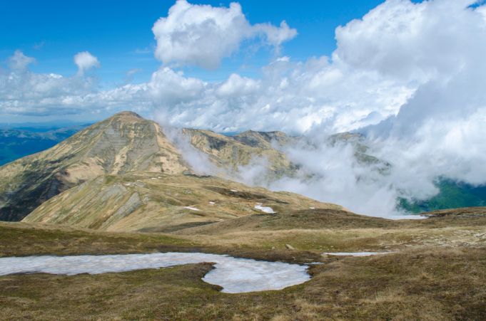
Amatrice, in the province of Rieti, is known not only for its namesake dish, a symbol of Lazio cuisine in Italy and around the world, but also for the terrible earthquake that devastated the village on August 24, 2016 along with the town of Accumuli. Just outside of the city of Rome, here you can discover some great trekking routes along the 2,458– meter climb of Gorzano, the highest peak in Lazio, as well as on the slightly lower altitudes of Cima Lepri, Pizzo di Sevo and Pizzo di Moscio. However, they are recommended for more experienced hikers.
Also read: Pope visits Amatrice
The walks in the woods and towards the waterfalls that roar between spring and summer are more accessible, but require attention to the slippery ground. Under the Laga mountains, which are the highest in Lazio, there are many beautiful paths, very well marked. On the other side of the basin you can trek around the Pantani lakes, in the territory of Accumoli, and the solitary Monte Pozzoni, which dominates the small town of Cittareale and its castle. You can follow the Cammino delle Terre Mutate, the Sentiero Italia, admire the waterfalls of the Scalette and Barche and stop at the Santuario dell’Icona Passatora, rich in frescoes.
Getting there from Rome: By car: About 2 hours.
Journey time: three quarters of an hour from Retrosi to Capricchia; an hour and a half from Capricchia to the junction for Monte Gorzano; an hour from the junction for Monte Gorzano to Colle Piano; an hour and a quarter from Colle Piano to San Martino; three quarters of an hour from San Martino to Retrosi.
Route length: 11 kilometers
Best time to do it: from May to October
9. Archaeological Park of Vulci
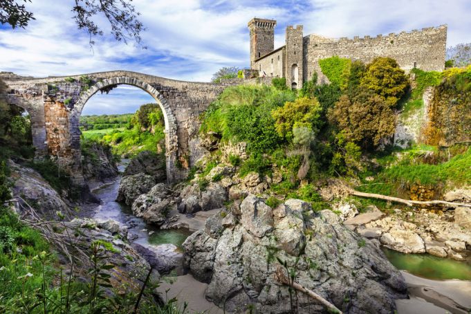
Vulci became famous in 1828, when a farmer broke through an Etruscan tomb with his plow. Since then looting and vandalism have damaged the remains of this very rich archaeological area. But today, thanks to the Municipality of Montalto di Castro, the ruins and the Archaeological Park are protected in part because of the taxes paid by the nearby Enel electrical center.
Also read: I Predatori dell’Arte at Villa Giulia
The course along the river and the Pellicone Lake, surrounded by rocky walls, make the area charming. The Castle and the magnificent Abbadia Bridge, which crosses the Fiora gorge upstream on the Pellicone Lake, and houses a small archaeological museum, are all worth a visit. Ph: leoks / Shutterstock.com
How to get there: By Car: 1 hour and 30 minutes from Rome
Walking time: three quarters of an hour from the ticket office to the Fiora; half an hour from the Fiora to the Laghetto del Pellicone; half an hour from the Laghetto del Pellicone to the ticket office.
Route length: 4 kilometers
Best time to do it: all year round
Visits: François Tomb (please contact the park ticket office) and the Archaeological Museum of the Abbadia Castle
10. Appia Antica
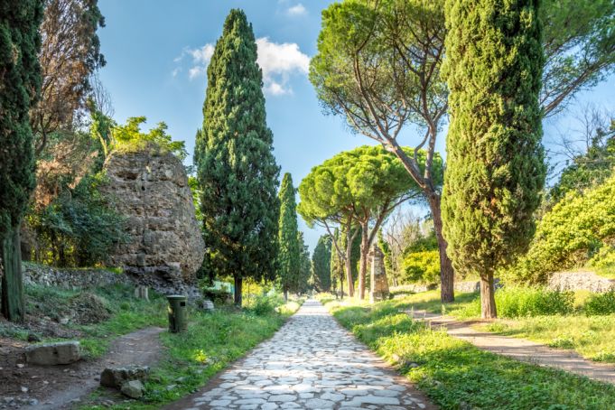
The Appia Antica is one of the wonders of Rome and Italy. Still, today, the ancient Regina Viarum (“Queen of Roads”) is surrounded by extraordinary monuments. It is bordered by six of the eleven aqueducts of Imperial Rome. All around it lies the Roman Countryside. Inaugurated in 312 BC, the Via Appia connected Rome with Benevento and the ports of Puglia. Today the Appia Antica offers to Romans and tourists a fantastic walk.
Also read: Living on the Appia Antica
You just have to pay attention to the passing vehicles. On weekdays, at any time of the year, it is best to reach the Mausoleum of Cecilia Metella by bus and walk along the ancient basolato of Capo di Bove, or start the walk by crossing the Caffarella. Bring snacks or have a picnic along the way!
How to get there: By Bus: From Piazza Venezia take the 118 public bus to Basilica S. Sebastiano. By Car: About 20 minutes from the city center
Walking time: one hour from Piazzale Numa Pompilio to Capo di Bove; three quarters of an hour from Capo di Bove to Casal Rotondo; one quarter of an hour from Casal Rotondo to Via Appia Nuova; three quarters of an hour from Casal Rotondo to Capo di Bove; one hour from Capo di Bove to Piazzale Numa Pompilio.
Route length: 8 kilometers
Best time to do it: all year round
Visits: Mausoleum of Cecilia Metella, Villa di Capo di Bove, Villa dei Quintili


